A Sizzling Start to Summer
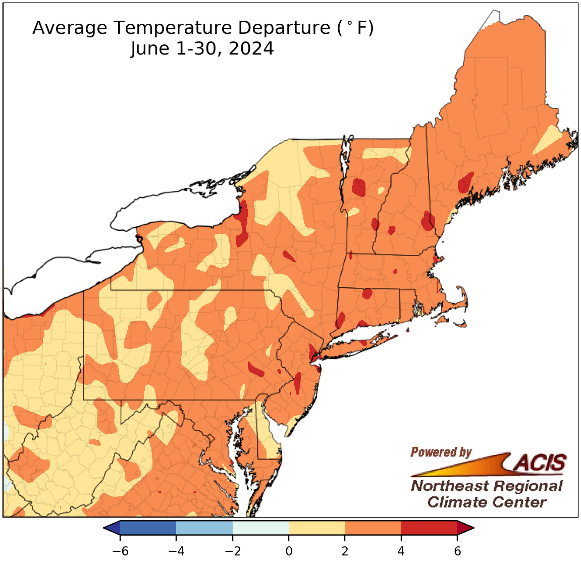
June average temperatures ranged from near normal to 6°F above normal.
The summer season started with a hot June, with average temperatures ranging from near normal to 6°F above normal. At the Northeast’s 35 major climate sites, June average temperatures ranged from 1.8°F above normal in Allentown, PA, and Portland, ME, to 5.2°F above normal in Hartford, CT. This June was record hot for four major climate sites - Hartford, CT; Caribou, ME; Bridgeport, CT; and Islip, NY - and among the 20 hottest for the rest of the sites.
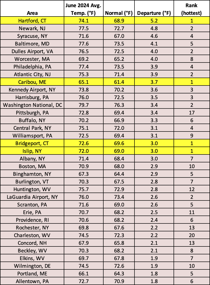
This June was record hot for four major climate sites and among the 20 hottest for the remaining sites.
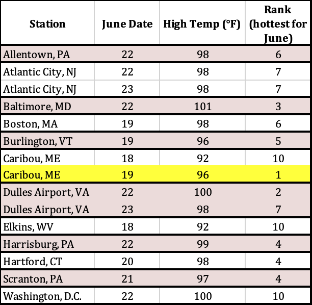
During an exceptionally hot period in mid-June, several sites had one of their 10 hottest June temperatures on record including Caribou, ME, which was record hot.
While much of the month featured above-normal temperatures, the period from around June 18 to 23 was particularly noteworthy. During this period, Caribou, ME, tied its all-time hottest temperature on record and several climate sites had one of their 10 hottest June temperatures on record. Unusually warm low temperatures offered little reprieve from the daytime heat. Burlington, VT, and Caribou, ME, tied their all-time warmest low temperatures on record, while Dulles Airport, VA, set a new record for its warmest low temperature for June. In addition, low temperatures during the period ranked among the 10 warmest on record for June at multiple sites. There were several other impressive stats from the period including Dulles Airport, VA, had never recorded a low of 75°F or higher in June until this heat wave when it recorded two and that Binghamton, NY, recorded two days with a low temperature of 70°F or higher, tying its greatest number for June.
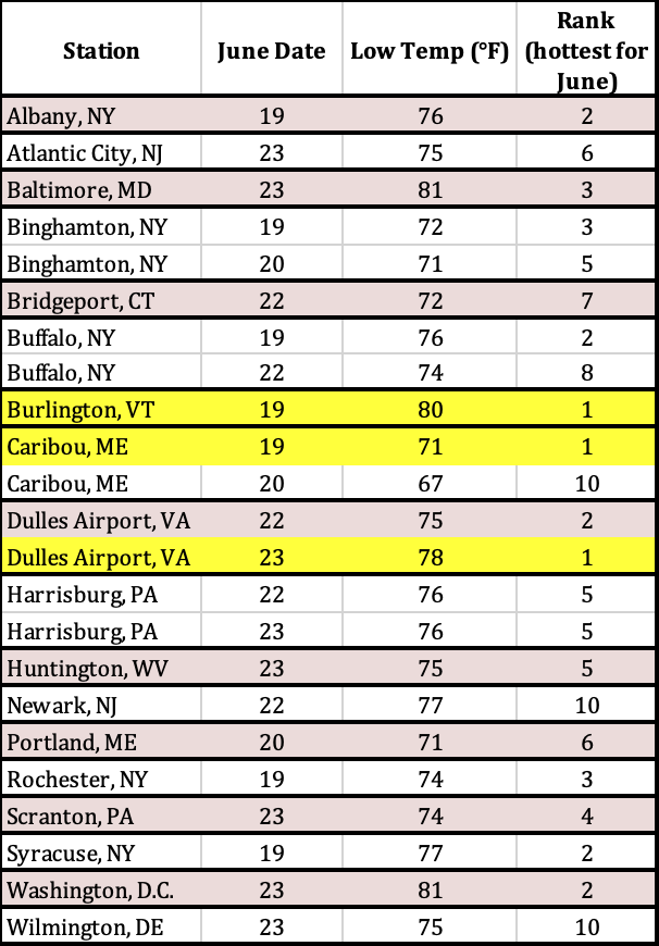
Low temperatures were unusually warm during the mid-month heat wave, with three sites setting/tying records and multiple others having one of their 10 warmest low temperatures for June.
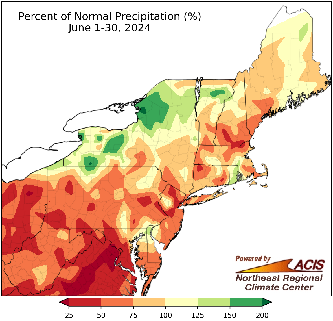
June precipitation ranged from less than 25% of normal to 200% of normal.
The fickle nature of summertime convective rainfall produced a wide range of precipitation amounts across the Northeast this June, from less than 25% of normal in southern Maryland to 200% of normal in parts of western and northern New York. At the region’s 35 major climate sites, June precipitation ranged from 16% of normal at Dulles Airport, VA, to 152% of normal in Erie, PA, with 23 of the sites being drier than normal. This June ranked among the 20 driest Junes on record for eight major climate sites but among the 20 wettest for five other sites.
Drier-than-normal conditions in the Mid-Atlantic led to the rapid introduction/expansion of moderate drought and abnormal dryness, particularly in West Virginia and Maryland. For instance, in one week, Maryland’s percent area in drought went from 5% to 61%, while West Virginia’s drought coverage expanded from 5% to 59%. Impacts such as record-low streamflow and/or groundwater levels, requests for water conservation, burn bans, and heavy reliance on irrigation were noted in parts of the Mid-Atlantic.
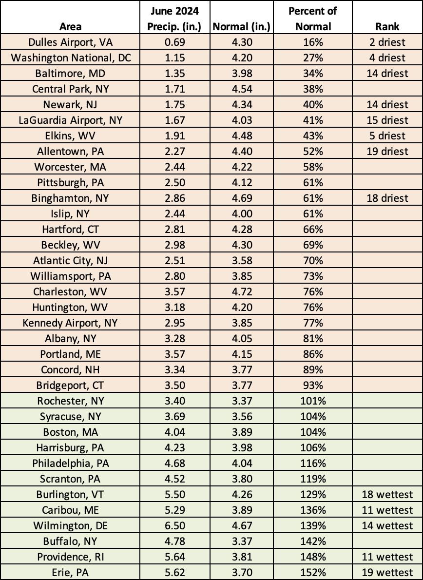
This June ranked among the 20 driest Junes on record for eight major climate sites but among the 20 wettest for five other sites.
In addition, June featured multiple rounds of severe weather including a tornado outbreak in Maryland and eastern West Virginia on June 5, daily severe weather during the mid-June heat wave, several tornadoes and damaging straight-line winds on June 26, and storms that produced damage (that is still being surveyed) on June 29 and 30. Information on these severe weather events, as well as more on the June heat wave, will be included in our June summary which will be published around July 5 on our website.
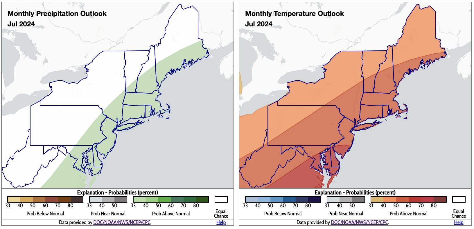
NOAA’s Climate Prediction Center favors above-normal precipitation for coastal areas (shaded green) and above-normal temperatures for the entire Northeast (shaded orange and red). Click to enlarge.
The July outlooks from NOAA’s Climate Prediction Center show an increased likelihood of above-normal precipitation for coastal areas tied to long-term climate trends and the potential for increased tropical moisture. The Northeast is expected to average out to be warmer than normal for July.